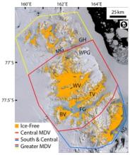
The McMurdo Dry Valleys are the largest ice-sheet-free portion of Antarctica. But just how large are they? Published mentions of the area of the McMurdo Dry Valleys (MDV) are highly variable: 2,000 km2 (Chinn, 1988), 2,500 km2 (McKendry & Lewthwaite, 1992), 3,000-4,000 km2 (Keys & Williams, 1981), 4,000 km2 (Priscu, 1998), 4,500 km2 (Priscu et al., 1999), 4,800 km2 (Doran et al., 2002), 6,000 km2 (Seybold et al., 2009), 6,692 km2 (Bockheim & McLeod, 2008), 6,700 km2 (Bockheim et al., 2007), 15,000 km2 (Hopkins et al., 2006). The goal of this list is not to single out individual authors, but rather, to highlight the range of published values. These area estimates derive from diverse sources, including remapping of USGS satellite image maps or GIS tabulations of the areas of mapped surface features (e.g., Bockheim et al., 2007), but are overwhelmingly reported without citations of mapping methodology.
Some of this variability can be attributed to which portions of the MDV are considered. For example, including ice-free regions on the Brown Peninsula increases MDV area (Bockheim et al., 2007), while defining the MDV as the region bounded by the Ferrar and Mackay glaciers reduces their area (Denton et al., 1993). Likewise, inclusion of ice-covered areas (e.g., glaciers, snow packs) will increase the size of the MDV, while only mapping bare surfaces reduces their size.
These divergent area values propagate through the scientific literature, producing a nearly eight-fold range of geographic uncertainty. Accurately determining the ice-free area of the McMurdo Dry Valleys is essential for planning management and science operations in this complex natural laboratory. This note describes an attempt to determine the ice-free area of the McMurdo Dry Valleys using satellite image data.