Research sites

Huey Creek at F2

USGS site 2; coordinates taken from 1996-97 GPS measurements at center of weir Parent Stream: Huey Creek Provenance : GPS96-97.DOC ID: huey_f2

Coordinates: 

Latitude: -77.604897000000
Longitude: 163.127410900000

Huey Creek at mouth

Coordinates taken from 1996-97 GPS measurements at center of creek where it enters Lake Fryxell Parent Stream: Huey Creek Provenance : GPS96-97.DOC ID: huey_mouth

Coordinates: 

Latitude: -77.605888000000
Longitude: 163.129974400000

Hughes Glacier

Hughes Glacier is a small alpine glacier flowing toward Lake Bonney in Taylor Valley from the Kukri Hills on the south. Named for Professor McKenny Hughes.

Coordinates: 

Latitude: -77.740379333496
Longitude: 162.491653442383

Kaki Pond 3

The Kaki Pond 3 is an ce-covered pond with a moat less than a meter. It is in the Taylor Bonney, looks like the Bonney Basin.Code: MP3Area:5,318Temperature: 

Coordinates: 

Latitude: -77.700569152832
Longitude: 162.711425781250

Kaki Pond 4

The Kaki Pond 4 is located in the uplands of the Boney Basin, in the Taylor Valley, is ice covered with a moat less than a meter.

Code: MP4

Area:14,012

Temperature: 2.4 celsius

Coordinates: 

Latitude: -77.696022033691
Longitude: 162.716186523438

Labyrinth Pond 4

The Labyrinth Pond 4 is located in the Wright Valley. Ice-covered, heavily shaded, lense-shaped.

Code: LAB4

Area: 25,805

Temperature: 2.6 celsius

Coordinates: 

Latitude: -77.560478210449
Longitude: 161.063613891602

Lake Bonney

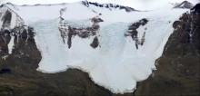
Lake Bonney occupies a glacially scoured bedrock basin in Taylor Valley. It is located at the head of the valley and is perennially ice-covered. The lake has two basins (lobes) connected by a narrow, shallow channel. There are no surface outflows; the only known water loss is through ice ablation (evaporation, sublimation and physical scouring). The lake is bordered to the north by the Asgard Range and to the south by the Kukri Hills. Mountain and cirque glaciers occupy hanging valleys between these peaks and supply meltwater intermittently to the lake during warmer periods in summer. The largest source of meltwater, however, is from the Taylor Glacier, which extends from the polar ice-cap and terminates in the western end of the west lobe of Lake Bonney. Valley: Taylor Distance to Sea : 25 Maximum Length (km): 7 Maximum Width (km): 0.9 Maximum Depth (m): 40 Surface Area (km^2): 4.3 Ice Thickness Average Surface (m): 2.8 - 4.5 Volume (m^3 * 10^6): 64.8

Coordinates: 

Latitude: -77.719100952148
Longitude: 162.371994018555

Pages