Field data collection: Field data collection was restricted to GPS mapping of the stream and anabranch locations, and discharge measurements made at several locations in the channel and monitored continuously at the downstream gaging station.
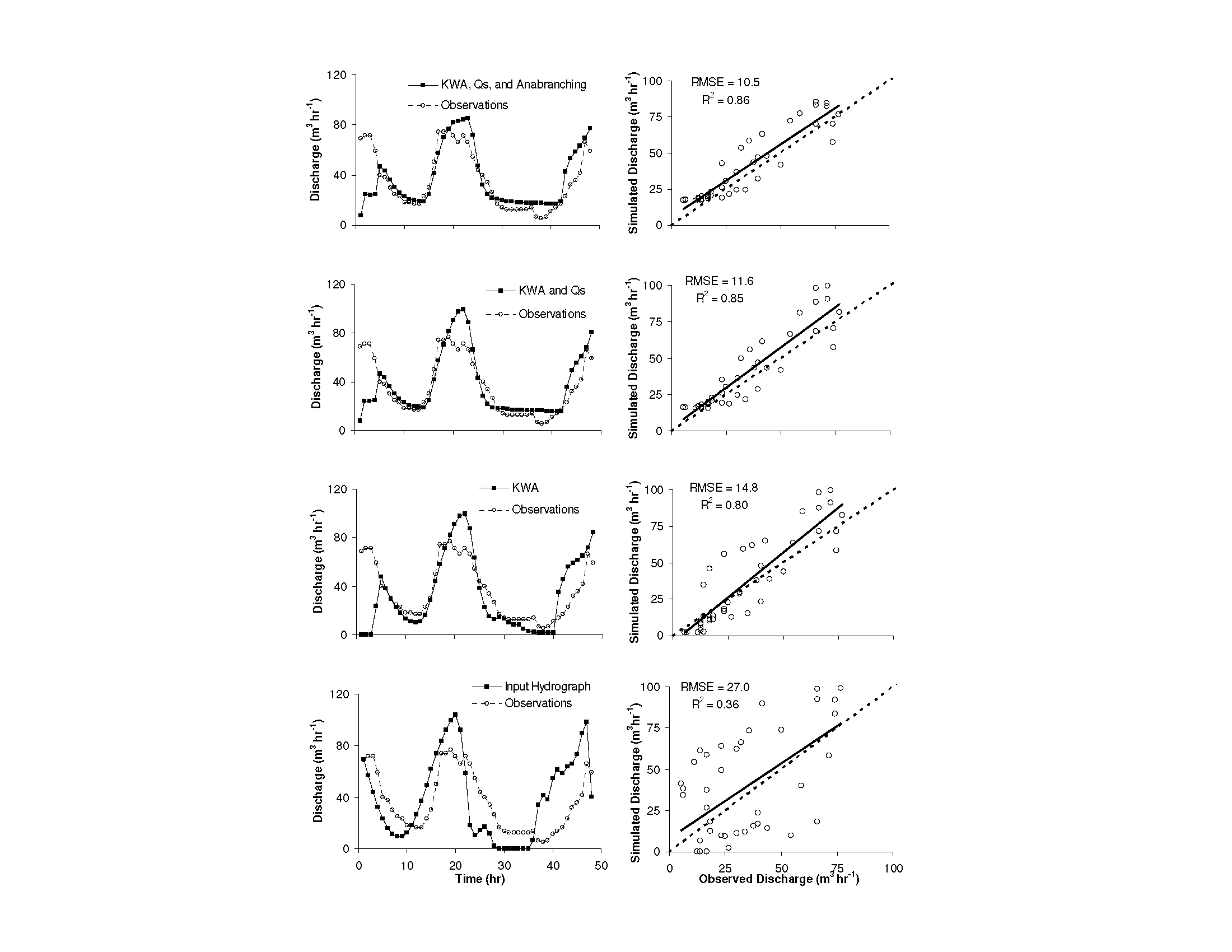
Model approach: The inflow hydrograph was estimated based on the relationship between incoming solar radiation and discharge in a short stream without large subsurface storage potential (Canada Stream). Stream slope was calculated from the GPS survey and GIS data available on the mcmlter website, and roughness was calculated by solving Manning’s equation based on rod and pygmy measurements. Channel morphology was also determined from rod and pygmy measurements. The outflow hydrograph was known from the downstream gage on Huey Creek. Hydraulic conductivity, evapotranspiration, and the discharge at which stream braids filled with water were calibrated to minimize the difference between the inflow and outflow hydrographs.
Modeling code used: MODFLOW for subsurface flow (water.usgs.gov/nrp/gwsoftware/modflow.html) , coupled with SFR2, a stream flow routing package (pubs.usgs.gov/tm/2006/tm6A13/)
Model input files: The final run template is included. This contains the model domain, hydrologic inputs and streamflow routing rules (.sfr file). The three data sets can be run from this by 1) adjusting hydraulic conductivity in the .lpf and .sfr files (10 m/hr for subsurface flow or 10-6 for no subsurface flow), and 2) turning on or off the anabranches by setting the discharge threshold at which the anabranches fill (65 m3/hr for anabranching 650 for no anabranching).
Simulation output: One of the three final runs is included. This contains the hydrographs at the top and bottom of the anabranching reach and at the gage (fin2,fin7,and fin8.ggo, respectively) and the summary (.lst) file. Aquifer hydraulic head (.fhd) and the budget file (.bud) were not included because of the large file size (examples of .fhd results for active and inactive anabranching conditions (ie, high and low flow) can be found in the publication). A results summary file is included ‘ResultsSummaryCalcs.xlsx’, which includes the method for comparing model runs and quantifying error, and also includes calculations for storage change and exchange rate. The methodology is fully explained in the publication.