Research sites

Taylor Valley

This is the Taylor Valley, a subjectively approximated contour by San Gil. We use this to denote the geographical extent of studies that encompass the whole Taylor Valley.

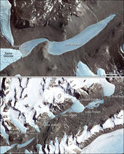
According to Wiki contributors, the Taylor Valley is the southernmost of the three large Dry Valleys in the Transantarctic MountainsVictoria Land, located west of McMurdo Sound. The valley extends from Taylor Glacier in the west to McMurdo Sound at Explorers Cove at the northwest head of New Harbour in the east and is about 29 kilometres (18 mi) long. It was once occupied by the receding Taylor Glacier, from which it derives its name. Taylor Valley contains Lake Bonney in the west (inward), and Lake Fryxell in the east (coastward), and Lake HoareLake Chad, Mummy Pond and Parera Pond close together between the two. Further east of Lake Bonney is Pearse Valley. Taylor Valley is separated from Wright Valley in the north by Asgard Range, and from Ferrar Glacier in the south by Kukri Hills.

Coordinates: 

Latitude: -77.670323633034
Longitude: 162.699072084430

Transect 1 at Andersen Creek

Transect by Andersen Creek near Gage Moss Site M-01, H01Simm-G, H1 Transect 1 Points T011 and T012 mark the start and end of the transect. Start : IDs: 1ANDRSNT011 Ellipsoid: 23.73 ORTHOMETRIC HT (m) 78.97 End: ID: 1ANDRSNT012 Ellipsoid: 22.64 ORTHOMETRIC HT (m) 77.88 File provenance: strm-clg.txt

Coordinates: 

Latitude: -77.623054504395
Longitude: 162.907073974609

Transect 10 at Bowles Creek

Transect by Bowles Creek near gage Moss Site M-10, F10Bowl-G Transect 10 Points T101 and T102 mark the start and end of the transect. Start : IDs: 10BOWLEST101, Ellipsoid: -25.54 ORTHOMETRIC HT (m) 29.7 End: ID: 10BOWLEST102 Ellipsoid: -24.01 ORTHOMETRIC HT (m) 31.24 File provenance: strm-clg.txt

Coordinates: 

Latitude: -77.623123168945
Longitude: 163.057144165039

Transect 11 at Huey Creek

Transect by Huey Creek near gage Moss Site M-11, F11Huey-G Transect 11 Points T111 and T112 mark the start and end of the transect. Start : IDs: 10BOWLEST111, Ellipsoid: -14.09 ORTHOMETRIC HT (m) 41.15 End: ID: 10BOWLEST112 Ellipsoid: -12.91 ORTHOMETRIC HT (m) 42.31 File provenance: strm-clg.txt

Coordinates: 

Latitude: -77.601875305176
Longitude: 163.122131347656

Transect 12 at Von Guerard Stream

Transect by Von Guerard Stream at gage Moss Site M-12, F12Vong-G Transect 12 Points T121 and T122 mark the start and end of the transect. Start : IDs: 12VGGAGET121, Ellipsoid: -30.67 ORTHOMETRIC HT (m) 24.53 End: ID: 12VGGAGET122 Ellipsoid: -31.35 ORTHOMETRIC HT (m) 23.87 File provenance: strm-clg.txt

Coordinates: 

Latitude: -77.609367370605
Longitude: 163.254180908203

Transect 13 at Priscu Stream

Moss Site 13 Transect 13 Points T131 and T132 mark the start and end of the transect. Start : IDs: 13PRISCUT131, Ellipsoid: 16.79 ORTHOMETRIC HT (m) 71.96 End: ID: 13PRISCUT132 Ellipsoid: 21.49 ORTHOMETRIC HT (m) 76.64 File provenance: strm-clg.txt

Coordinates: 

Latitude: -77.696533203125
Longitude: 162.538528442383

Transect 14 at Lawson Creek

Transect by Lawson creek near gage Moss Site M-14, B14Laws-G Transect 14 Points T141 and T142 mark the start and end of the transect. Start : IDs: 14LAWSONT141, Ellipsoid: 24.08 ORTHOMETRIC HT (m) 79.13 End: ID: 14LAWSONT144 Ellipsoid: 30.05 ORTHOMETRIC HT (m) 85.08 File provenance: strm-clg.txt

Coordinates: 

Latitude: -77.720573425293
Longitude: 162.267852783203

Transect 15 at Bohner Stream

Transect by Boehner Stream at lower site. B15Bohn-L Transect 15 Points T151 and T152 mark the start and end of the transect. Start : IDs: 15BOHNERT151 Ellipsoid: 74.57 ORTHOMETRIC HT (m) 129.74 End: ID: 15BOHNERT152 Ellipsoid: 70.17 ORTHOMETRIC HT (m) 125.32 File provenance: strm-clg.txt

Coordinates: 

Latitude: -77.697319030762
Longitude: 162.561889648438

Pages